


Readsville Voting District, Callaway County, Missouri
About
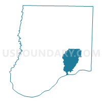
Outline

Summary
| Unique Area Identifier | 607309 |
| Name | Readsville Voting District |
| County | Callaway County |
| State | Missouri |
| Area (square miles) | 43.84 |
| Land Area (square miles) | 43.30 |
| Water Area (square miles) | 0.54 |
| % of Land Area | 98.77 |
| % of Water Area | 1.23 |
| Latitude of the Internal Point | 38.76829460 |
| Longtitude of the Internal Point | -91.78723700 |
Maps


Graphs
Select a template below for downloading or customizing gragh for Readsville Voting District, Callaway County, Missouri


Neighbors
Neighoring Voting District (by Name) Neighboring Voting District on the Map
- East Fulton Voting District, Callaway County, MO
- Hams Prairie Voting District, Callaway County, MO
- Mokane Voting District, Callaway County, MO
- Portland Voting District, Callaway County, MO
- Williamsburg Voting District, Callaway County, MO
Top 10 Neighboring County Subdivision (by Population) Neighboring County Subdivision on the Map
- East Fulton township, Callaway County, MO (10,231)
- St. Aubert township, Callaway County, MO (1,969)
- Auxvasse township, Callaway County, MO (1,000)
- Nine Mile Prairie township, Callaway County, MO (790)
Top 10 Neighboring Unified School District (by Population) Neighboring Unified School District on the Map
- Fulton School District, MO (19,130)
- North Callaway R-I School District, MO (6,857)
- South Callaway R-II Schools, MO (4,457)